to the cable cars
Top

Summer hiking tour: Sentiero Paul Grohmann Weg

Toblach
Add to favourites
Category
Difficulty
Intermediate
Activity time
4:11
Duration in hours
Distance
11.5
Distance in km
Suggested period
Jan
Feb
Mar
Apr
May
Jun
Jul
Aug
Sep
Oct
Nov
Dec
The path is dedicated to the famous alpinist Paul Grohmann. Especially recommended for advanced hikers.

The Paul Grohmann path is a hike in a picturesque, tranquil valley far from major tourism centres. In 1869 first climbers Paul Grohmann, Peter Salcher and Franz Innerkofler used this path to conquer the Große Zinne/Cima Grande.

Route info
Intermediate
Distance
11,5 km
Activity time
4 h 11 min
Ascent
1.068 m
Descent
148 m
Physical effort
Scenary
Highest point
2.324 m
Lowest point
1.404 m
Directions

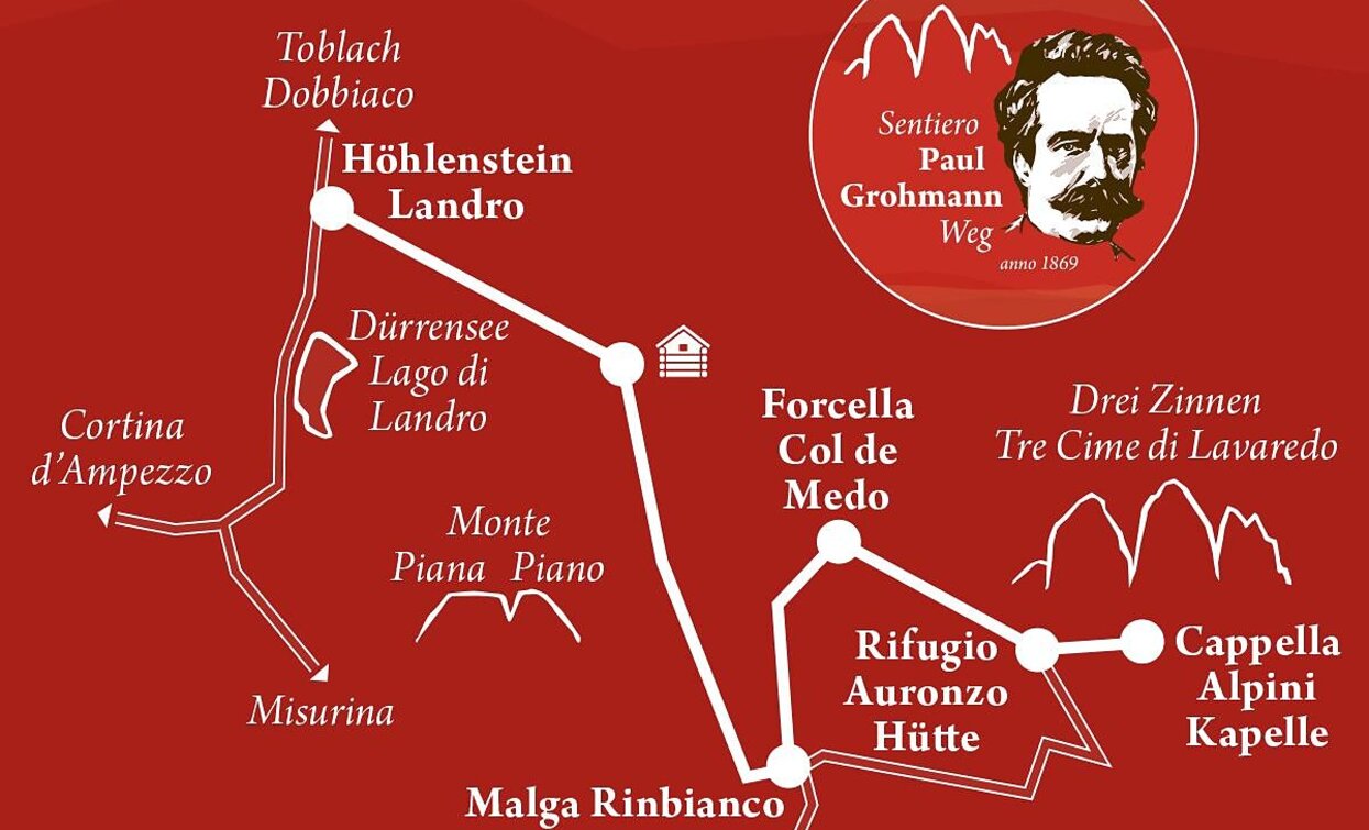
The hike starts at the car park View of the Three Peaks/Landro and follows path no. 102 through the Rienztal/Valle della Rienza valley, along the mountain stream to the hunting lodge. There the path no. 107 crosses the Rienz/Rienza streambed on the right and continues to the Malga Rinbianco hut  (open for refreshments). Above the hut, at the first bend of the toll road, path no. 105/A leads northwards to the intersection Forcella dell’Arghena. The hike continues on path no. 108/A to Forcella Col de Medo (2,324 m). On arrival at the south side of the Three Peaks, path no. 105 leads to the Auronzo hut and path no. 101 then on to the “Cappella Alpina“ with a memorial stone at the foot of the Three Peaks.

Hiking path no. 105 runs back to the starting point via Valle della Rienza/Rienztal valley. There is also a public bus service from Rifugio Auronzo.

The hike can be shortened by starting from Lago d’Antorno (above Misurina) and climbing via Malga Rinbianco.

public transportation

Accessible by public transport. The timetables are available on www.sii.bz.it.

How to get there

How to reach Toblach/Dobbiaco: https://www.drei-zinnen.info/en/dobbiaco/dobbiaco/contact-and-service/arrival-mobility.html

From Toblach in southern direction until the View of the Three Peaks/Landro.

Where to park

Parking places are available.

You might be interested in
Discover related tours
Innichen
Family hike: Source of the Drava (Drau) River
Distance 2,4 km
Activity time 45 min
Ascent 39 m
Descent 23 m
Status
Closed
Sexten
Hike: Moos - Kreuzberg pass
Distance 6,5 km
Activity time 2 h 00 min
Ascent 294 m
Descent 0 m
Bonner Hut | © @TVToblach, Dobbiaco
Intermediate
Add to favourites
Toblach
Summer-walk around the Bonner hut
Distance 13,8 km
Activity time 4 h 30 min
Ascent 1.084 m
Descent 1.084 m
Malga Cavallo/Rossalm | © Steiner Hubert, Braies
Intermediate
Add to favourites
Pragser Tal
Summer hiking tour - Ponticello/Brückele - Alpine hut "Malga Cavallo/Rossalm"
Distance 4,7 km
Activity time 2 h 14 min
Ascent 666 m
Descent 0 m
Toblach, Niederdorf
Family hiking tour: Niederdorf - Aufkirchen - Toblach - Niederdorf
Distance 10,7 km
Activity time 4 h 30 min
Ascent 600 m
Descent 800 m
Waldkapelle chapel | © TV Sexten - Christian Tschurtschenthaler, Sesto
Intermediate
Add to favourites
Sexten
Hike: From Sexten to the Waldkapelle chapel
Distance 1,9 km
Activity time 50 min
Ascent 213 m
Descent 4 m